New Website Coming Soon
Contact us at
james@dronephotographygroup.com
Aerial photography, videos and editing services for:
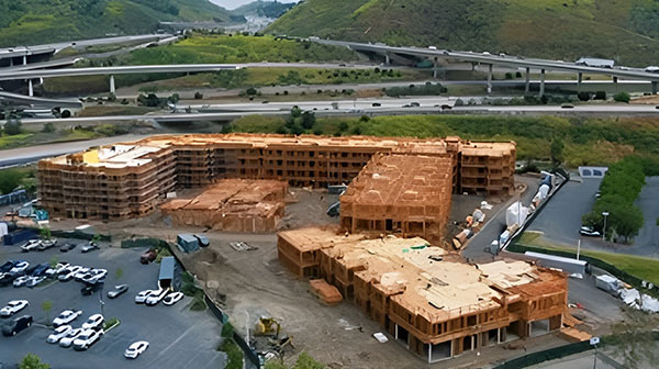
Construction – Progress, Monitoring, and Area Mapping
Solution: Drone Photography Group LLC provides comprehensive aerial solutions for commercial construction projects, enabling meticulous progress tracking, real-time monitoring, and accurate area mapping. Our high-resolution imagery and video capture every detail of a construction site, from foundational work to structural completion. We deliver precise visual documentation, including orthomosaic maps and 3D models, that allow stakeholders to assess progress against plans, identify potential issues early, manage resources efficiently, and ensure safety compliance. This detailed aerial data is invaluable for enhancing project oversight, facilitating communication, and making informed decisions throughout the construction lifecycle.
Industry: This service is vital for commercial construction companies, project managers, site supervisors, developers, and investors involved in commercial building projects. It supports proactive project management by offering continuous visual updates on site conditions, material inventory, and workforce activities. By providing an unparalleled perspective on construction progress and area dynamics, drone services from Drone Photography Group LLC help to keep projects on schedule and within budget, minimize costly rework, and improve overall operational efficiency in the commercial construction sector.
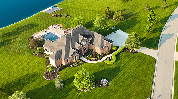
Commercial and Residential Real Estate
Solution: Drone Photography Group LLC provides unparalleled aerial perspectives for both residential and commercial properties, transforming how real estate is showcased and understood. Our high-resolution imagery and video tours capture the entire layout, landscaping, and surrounding environment, highlighting unique features, curb appeal, and strategic location. For residential properties, this dynamic visual content makes listings stand out and attracts potential buyers with stunning views of the home and neighborhood. For commercial properties, our drones capture extensive details of the property, its land, and its strategic placement within the surrounding commercial area, providing a comprehensive visual understanding of its scale, accessibility, and potential. This immersive content is crucial for highlighting a property’s value to investors and tenants, making all real estate listings more compelling, transparent, and visually engaging.
Industry: This service is indispensable for real estate agents, brokers, developers, investors, property managers, and homeowners across both the residential and commercial sectors. It offers an innovative and sophisticated method for presenting a diverse range of properties, from single-family homes and multi-unit dwellings to offices, retail spaces, industrial facilities, and large development sites. Drone photography accelerates the decision-making process for buyers and tenants by offering a clear, dynamic perspective that traditional photography simply can’t match, ultimately driving faster transactions and more effective marketing in the entire real estate market.
Agriculture Crop and Livestock Monitoring
Solution: Drones provide farmers with precise, real-time aerial data on crop health, irrigation issues, and livestock movement, enabling informed decisions that boost yields and improve animal welfare.
Industry: Farmers, agricultural cooperatives, agronomists, and livestock managers seeking to optimize efficiency, reduce waste, and increase productivity.
Utility and Power Line Inspections
Solution: Drones are perfect for utility and power line inspections, quickly spotting overheating components, failing insulators, or line faults. This ensures critical infrastructure remains reliable and prevents costly outages.
Industry: This service is vital for utility companies and infrastructure maintenance firms, allowing them to efficiently monitor and maintain power grids, ensuring consistent and safe energy delivery.
Roof Inspections
Solution: Drone roof inspections revolutionize roof assessment, using high-resolution imagery to identify issues like missing shingles or damaged flashing. This safe, efficient method provides precise data, allowing proactive repairs and preventing costly damage.
Industry: This cutting-edge approach benefits a broad spectrum: property managers, homeowners, insurance adjusters, and real estate professionals can all gain safer, more accurate, and efficient roof insights.
Solar Panel Inspections
Solution: Drone solar panel inspections use specialized thermal imaging to identify invisible hot spots or underperforming cells. This proactive, non-invasive assessment ensures your solar investment operates optimally, preventing costly downtime and maximizing energy output.
Industry: This advanced insight benefits solar farm operators by efficiently assessing vast arrays, commercial property owners ensuring system uptime, and homeowners verifying maximum power generation. Anyone relying on solar power can leverage drone inspections for optimal performance.
Custom Solutions
Search and Rescue/Public Safety
Solution: Drones offer a rapid, safe, and often indispensable tool for covering vast or dangerous terrain, significantly accelerating the search for missing persons in critical situations.
Industry: Emergency services, law enforcement agencies, and volunteer search and rescue organizations can vastly improve their operational capabilities and response times.
Industrial Facility Inspections
Solution: Drones safely and efficiently inspect hard-to-reach industrial infrastructure like pipelines, power lines, and tall structures, minimizing downtime and reducing human risk.
Industry: Manufacturing plants, energy companies, utility providers, and any industrial facility manager responsible for asset integrity and regulatory compliance.
Firefighting/Hotspot Detection (Post-Fire Mapping)
Solution: Drones equipped with thermal cameras can safely and quickly identify lingering hotspots after a fire is contained, preventing reignition and guiding targeted suppression efforts.
Industry: Fire departments, emergency management agencies, forestry services, and environmental protection teams involved in wildfire management and post-fire assessment.
Insurance Claim Support
Solution: Drones provide rapid, objective, and detailed aerial documentation of property damage, streamlining the claims process and ensuring accurate assessments for both policyholders and insurers.
Industry: Insurance companies, claims adjusters, property owners, and restoration services needing comprehensive visual evidence for damage assessment and dispute resolution.
Wildlife Monitoring and Anti-Poaching
Solution: Drones offer a non-invasive, efficient way to survey vast areas for wildlife populations, track animal movements, and detect poaching activities from a safe distance.
Industry: Conservation organizations, wildlife researchers, park rangers, and anti-poaching units dedicated to protecting endangered species and managing ecosystems.
Pipeline and Oil Field Inspections
Solution: Thermal imaging drones swiftly detect leaks and integrity issues across extensive pipeline and oil field infrastructure. This technology provides an efficient and crucial method for maintaining the safety and operational integrity of vital energy assets.
Industry: This solution is essential for oil & gas companies and pipeline contractors, enabling them to conduct rapid and thorough inspections of vast networks and ensure critical infrastructure remains secure and functional.